Contents.
| Chapter I. | The Thames | 1 | |
| Chapter II. | Springs | 21 | |
| Chapter III. | Rain and Dew | 39 | |
| Chapter IV. | The Crystallisation of Water; Snow and Ice | 55 | |
| Chapter V. | Evaporation | 66 | |
| Chapter VI. | The Atmosphere | 75 | |
| Chapter VII. | The Chemical Composition of Pure Water | 100 | |
| Chapter VIII. | The Chemical Composition of Natural Water | 115 | |
| Chapter IX. | The Work of Rain and Rivers | 130 | |
| Chapter X. | Ice and Its Work | 150 | |
| Chapter XI. | The Sea and Its Work | 166 | |
| Chapter XII. | Earthquakes and Volcanoes | 185 | |
| Chapter XIII. | Slow Movements of the Land | 205 | |
| Chapter XIV. | Living Matter and the Effects of Its Activity on the Distribution of Terrestrial Solids, Fluids, and Gases–Deposits Formed by the Remains of Plants | 217 | |
| Chapter XV. | The Formation of Land by Animal Agencies–Coral Land | 246 | |
| Chapter XVI. | The Formation of Land by Animal Agencies–Foraminifera Land | 260 | |
| Chapter XVII. | The Geological Structure of the Basin of the Thames; and the Interpretation of That Structure | 272 | |
| Chapter XVIII. | The Distribution of Land and Water | 299 | |
| Chapter XIX. | The Figure of the Earth–Construction of Maps | 317 | |
| Chapter XX. | The Movements of the Earth | 337 | |
| Chapter XXI. | The Sun | 359 |
[v]
Nearly nine years ago, I was invited, by the Managers of the London Institution, to take part in a series of courses of Educational Lectures; which were intended to initiate young people in the elements of Physical Science.
My course was to be the first of the series; and I made use of the opportunity, thus afforded me, to put into practical shape the ideas, which I had long entertained and advocated, respecting the proper method of approaching the study of Nature.
It appeared to me to be plainly dictated by common sense, that the teacher, who wishes to lead his pupil to form a clear mental picture of the order which pervades the multiform and endlessly shifting phenomena of nature, should commence with the familiar facts of the scholar's daily experience; and that, from the firm ground of such experience, he should lead the beginner, step by step, to remoter objects and to the less readily comprehensible relations of things. In short, that the knowledge of the child should, of set purpose, be made to grow, in the same [vi] manner as that of the human race has spontaneously grown.
I conceived that a vast amount of knowledge respecting natural phenomena and their interdependence, and even some practical experience of scientific method, could be conveyed, with all the precision of statement, which is what distinguishes science from common information; and, yet, without overstepping the comprehension of learners who possessed no further share of preliminary educational discipline, than that which falls to the lot of the boys and girls who pass through an ordinary primary school. And I thought, that, if my plan could be properly carried out, it would not only yield results of value in themselves, but would facilitate the subsequent entrance of the learners into the portals of the special sciences.
I undertook, therefore, to deliver twelve lectures, not on any particular branch of natural knowledge, but on natural phenomena in general; and I borrowed the title of "Physiography," which had already been long applied, in a different sense, to a department of mineralogy, for my subject; inasmuch as I wished to draw a clear line of demarcation, both as to matter and method, between it and what is commonly understood by "Physical Geography."
Many highly valuable compendia of Physical Geography, for the use of scientific students of that subject, are extant; but, in my judgment, most of the elementary works I have seen, begin at the wrong end, and too often terminate in an omnium gatherum of scraps of all sorts of undigested and unconnected information; thereby entirely destroying the educational value of that study which Kant justly termed the "propædeutic of natural knowledge."
[vii] I do not think that a description of the earth, which commences, by telling a child that it is an oblate spheroid, moving round the sun in an elliptical orbit; and ends, without giving him the slightest hint towards understanding the ordnance map of his own county; or any suggestion as to the meaning of the phenomena offered by the brook which runs through his village, or the gravel pit whence the roads are mended; is calculated either to interest or to instruct. And the attempt to convey scientific conceptions, without the appeal to observation, which can alone give such conceptions firmness and reality, appears to me to be in direct antagonism to the fundamental principles of scientific education.
"Physiography" has very little to do with this sort of "Physical Geography." My hearers were not troubled with much about latitudes and longitudes; the heights of mountains, depths of seas; or the geographical distribution of kangaroos and Compositæ . Neglecting such pieces of information–of the importance of which, in their proper places, I entertain no doubt–I endeavoured to give them, in very broad, but, I hope, accurate, outlines, a view of the "place in nature" of a particular district of England, the basin of the Thames; and, to leave upon their minds the impression, that the muddy waters of our metropolitan river; the hills between which it flows; the breezes which blow over it; are not isolated phenomena, to be taken as understood because they are familiar. On the contrary, I endeavoured to show that the application of the plainest and simplest processes of reasoning to any one of these phenomena, suffices to show, lying behind it, a cause, which again suggests another; until, step by step, the conviction dawns upon the learner that; to attain to even an elementary conception [viii] of what goes on in his parish, he must know something about the universe; that the pebble he kicks aside would not be what it is and where it is, unless a particular chapter of the earth's history, finished untold ages ago, had been exactly what it was.
It was necessary to illustrate my method by a concrete case; and, as a Londoner addressing Londoners, I selected the Thames, and its basin, for my text. But any intelligent teacher will have no difficulty in making use of the river and river basin of the district, in which his own school is situated, for the same purpose.
The lectures on Physiography were delivered at the London Institution in I869; and I repeated them, at South Kensington, in 1870. Verbatim reports were taken on the former occasion, as it was my intention to publish the course. But I am sorry to say that, in this, as in other cases, I have found a great gulf fixed between intention to publish and its realization.
Seeing a book through the press is a laborious and time-wasting affair; greatly aggravated, in cases such as the present, by the necessity of superintending the execution of maps and figures. And, as I never could muster up the courage, or find the time, to undertake the business, the manuscript remained untouched until last year.
I then had the good fortune to be able to obtain the services of my friend Mr. Rudler, with whose extensive knowledge of various branches of physical science, I was well acquainted; and, in whose conscientious accuracy, as an editor, I knew I could place implicit confidence.
In preparing the substance of the lectures for the press, [ix] Mr. Rudler has entirely fulfilled my expectations, and has made many valuable suggestions and additions. I have entirely rewritten such parts of the work as I thought I could improve; I have added to others; and I have carefully revised the proofs of every chapter.
I trust therefore that the book may be useful to both learners and teachers; but, I am most concerned, that the latter should find in it the ground-work of an introduction to the study of nature, on which their practical experience will enable them to erect a far better superstructure than that which I have been able to raise.
London, November, 1877
PREFACE TO THE THIRD EDITION.
The large demand for this work for educational purposes, during the last three years, has suggested the issue of a new and cheaper edition, which has been carefully revised .
I beg leave to offer my thanks to various correspondents who have called my attention to errors of the press, or ambiguities of expression in the former editions.
London, June, 1880.
[1]
No spot in the world is better known than London, and no spot in London is better known than London Bridge. Let the reader suppose that he is standing upon this bridge, and, needless of the passing stream of traffic, looks down upon the river as it runs below. It matters little on which side of the bridge he may chance to stand; whether he look up the river or down the river, above bridge or below bridge. In either case he will find himself in the presence of a noble stream measuring, when broadest, nearly a sixth of a mile from bank to bank. The quantity of water under London Bridge varies considerably, however, at different seasons, and even at different hours on the same day. When the water is highest, the greatest depth is about thirty feet and the width 800 feet; when the water is lowest, the greatest depth is something like twelve feet and the width only 650 feet. This variation in the volume of water shows that the river is not at rest, and that its surface is, in fact, alternately rising and falling. Moreover, apart from the local agitation due to traffic, apart too from the surface ripples [2] raised by the passing breeze, the whole body of water is in a constant state of motion. At one time in the day the water sweeps down below bridge in the direction of Greenwich and far onwards to the Nore; after this movement has been continued for some hours, it gradually slackens, and the water comes almost to a stand-still; then the motion begins afresh, but its direction is reversed, the water flowing this time towards Westminster and far away up the river; but, after a while, this motion slowly subsides, and is followed once more by renewed movement in a contrary direction.
Every one knows that this regular backward-and-forward movement of the great mass of water is due to tidal action. For about seven hours, during ebb-tide, the water of the Thames runs down towards the sea; and for about five hours, during flood-tide, the movement takes place in the opposite direction, the water being then driven up the river. At the end of the ebb-tide the river is shallowest; at the end of the flood tide it is deepest. The water at London Bridge is consequently twice in every four-and-twenty hours at its highest and twice at its lowest level.
As we go up the river, we find the effect of the tide gradually diminishing, until at length it ceases to be felt. In point of fact, the tidal movement has no influence beyond Teddington Weir, some nineteen miles above London Bridge. The very name Teddington is indeed said to be a corruption of "Tideend-ton," the town where the tide ends. Up to Teddington, then, the Thames is a tidal river, the water rising, and falling, and moving, first in one direction and then contrariwise, at definite intervals. The flood tide occupies about two hours in coming up from the Nore to London, a distance of about 40 miles; that is to say, it is high water at London Bridge two hours later than at the Nore. Then it takes two hours [3] more for the gradual rise of the water to its highest level, to travel onwards from London to Teddington, though the distance between these two points is less than twenty miles. The rise of the level of the surface of the Thames, which thus passes with great rapidity from the Nore towards Teddington, is accompanied by a much slower general motion of the water in the same direction, which constitutes the upward current of the tide; while a downward current in the opposite direction attends the fall of the water during the ebb.
Floating bodies are therefore carried towards Teddington, during the flood, and towards the Nore, during the ebb. It is almost needless to add that this tidal action is of vast service to the port of London, since barges, lighters, and other boats are thus enabled at certain periods of the day to float up or down the river with little or no expenditure of power on the part of the boatmen.
Above Teddington Weir the motion of the river is totally different from that which is observed at London Bridge. There is no alternate backward-and-forward motion, no regular rise and fall of the water, but the river flows onwards in one constant direction, always running down towards London. Careful observations at Teddington have shown that, with the water at ordinary summer-level, about 380 million gallons1 flow over the weir every four-and-twenty hours. This vast volume of water is swept down past London, and ultimately carried out to sea. As the ebb-tide runs for about seven hours, whilst the flood lasts only five, it is clear that much more water runs down than flows up; and it is in this way that the vast volume of water sent down from above Teddington drains away seawards.
[4] In seeking the origin of the water thus brought down by the Thames, it is necessary to trace the river to what is commonly called its "source." On ascending, it is observed that the river grows smaller, the volume of water becoming less and less. Thus, at Teddington, the Thames is only 250 feet wide at high water, whilst its width at London Bridge is about 800 feet. Following the many windings of the river past Windsor, Reading, and Oxford, we observe the stream still growing more narrow and more shallow, until at Lechlade, in Gloucestershire, 146 miles from London, the Thames ceases to be navigable. At Lechlade the quantity of water running down the river has been roughly estimated at something like a hundred million gallons per day, or only about one-fourth the quantity flowing over Teddington Weir. The main stream splits up at Lechlade into a number of smaller streams, forming the "head-waters" of the river, and it is by no means easy to say which of these streams should be followed up in seeking the true source of the Thames. Nor does it much matter, for the origin of any one of them is much the same as the origin of any of the others. It is usual, however, to single out one of these streams, which takes its rise in a spring near Cirencester, about 170 miles from London Bridge, and is dignified with the name of Thames Head.
Although the spring at Thames Head is thus popularly called the "source" of the river, it should be remembered that the quantity of water delivered by this spring is quite insignificant when compared with that derived from the numerous streams which flow into the Thames at various points along its course. Every tributary helps to swell the bulk of the river by discharging its water into the main stream; yet it does not [5] follow that the river is necessarily increased in width by the influx of this water, for it often happens that the additional supply is carried off by increased rapidity of flow. As the Thames rolls along, it receives a number of these feeders, or affluents,2 which empty themselves into the river, some on one side and some on the other.
It is obviously convenient to have some ready means of distinguishing the two banks of a river. For this purpose, geographers have agreed to call that bank which lies upon your right side as you go down towards the sea the right bank, and to call the opposite side the left bank. All that you have to do then, in order to distinguish the two sides, is to stand so that your face is in the direction of the mouth of the river, and your back consequently towards its source, when the right bank will be upon your right hand and the left bank upon your left hand. At Gravesend, for example, the right bank is that which forms the Kentish shore, while the left bank is on the Essex side. With reference therefore to the rivers tributary to the Thames, it is said that the Churn, the Colne, the Leach, the Windrush, the Evenlode, the Cherwell, the Thame, the Coln, the Brent, and the Lea empty themselves into the Thames on the left bank; and the Rey, the Cole, the Ock, the Kennet, the Loddon, the Wey, the Mole, and the Darent, open into the river on its right bank. The relative positions of these affluents, and their relation to the Thames, may be seen in the map given in Plate I.
If a person in a balloon passed at a great height over any [6] part of the earth's surface, and sketched in outline what he saw directly below, his sketch of a flat surface like this page would be called a map. When the portion of country thus delineated is but small, the sketch is generally termed a plan ; and if the area depicted consist chiefly of water instead of land, it is called a chart. Hence we commonly speak of the plan of an estate, the map of a country, the chart of an ocean. A map of the Thames, then, is simply an outline-sketch of the river and neighbouring portion of the earth's surface, as would be seen from a balloon passing at a great height directly over the country. It is the common practice to draw maps in such a position that the north is towards the top, and the south towards the bottom; while the east lies on the right hand of the person who looks at the map, and the west lies on his left hand. By simply looking then at the map, forming Plate I., it is seen at once that the Thames, though taking–like most rivers–an irregular course, winding first in one direction and then in another, nevertheless has, on the whole, a west-and-east course; it flows, in short, from the west towards the east. At the same time it is seen that the left shore of the river is its northern bank, and the right shore its southern bank. It is clear, too, that the tributaries on the left or north side flow generally from north to south, whilst those on the right or south side run generally from south to north.
These terms–north and south, east and west–are terms which have a meaning quite independent of local circumstances, and indicate definite directions which can be determined in any part of the world and at all times. When, in the early part of this chapter, we used the local expressions "up the river" and "down the river," "above bridge" and "below bridge," it was assumed that the reader [7] was familiar with the Thames. But to a perfect stranger, one who had never seen the river and knew nothing of London Bridge, such a method of description would be unintelligible. By employing, however, the terms north and south, east and west, we are using expressions that are familiar to all educated people, since they refer to standards of direction universally recognised. It is desirable to explain how these cardinal points may be determined.
Of the four points, the south is perhaps the most easily found, at least on a sunshiny day. Every morning the sun appears to rise slowly in the sky, and mounts to its greatest height at noon. At the instant of reaching its greatest height, or in other words at exact noon, the sun is precisely in the south. If, then, you place yourself in such a position as to have the sun shining full in your face at that particular time, you must be facing south; and you will consequently have your back to the north, your right hand towards the west, and your left towards the east.
As true noon does not always coincide with 12 o'clock, as indicated by an ordinary timekeeper, it is necessary to explain how it may be determined. Thrust a stick vertically into the ground, and observe, at different hours of the day, the length and direction of its shadow cast by the sun. When the sun is rising in the sky, the shadow is thrown towards the west; and when the sun is going down, it is thrown towards the east; at noon, however, it inclines neither to the east nor to the west, but falls exactly in a north-and-south line; and, moreover, the shadow is then shorter than at any other time. If, therefore, you observe when the shadow is shortest, that time will be exactly noon. The line indicated by the shadow at noon is known as the [8] meridian line or mid-day line . That end of the shadow-line which is towards the sun points to the south, and the opposite end to the north. If then a line be drawn anywhere at right angles across the shadow, the right-hand end of the cross-line, as you look to the south, points towards the west, and the left hand towards the east.
It is not easy, however, by merely looking at the shadow, to say when it is exactly reduced to its shortest length. It is well, therefore, to observe the shadow at some time in the forenoon and mark its length–say by sticking a peg in the ground, and then, in the afternoon, to observe the [9] shadow again, when it has reached exactly the same length. The afternoon shadow will then be just as much on one side of the meridian line as the forenoon shadow was on the other side. The mid-day line, or line which runs due north and south, will therefore be exactly half-way between the two shadows.
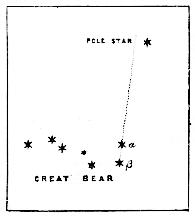
But it is by no means necessary to have daylight in order to discover the direction of the cardinal points. If you look up into the heavens on a clear starry night, you will have no difficulty, in this part of the world, in finding that curious group of seven bright stars known as Charles's Wain, forming part of the Great Bear (Fig. 1). A line drawn through two of these stars (B, a) will, if prolonged to about five times its length, pass very close to the famous Pole-star. 2 On a clear night, all the groups of stars appear to move slowly round a certain motionless point in the sky, which is the north pole of the heavens. That point of the earth which is directly opposite the celestial north pole is the north pole of the earth. If the explorers in the Alert and Discovery could have reached the north pole, they would have found the pole-star almost directly overhead. [10] It must be remembered, however, that the pole-star is not exactly at the north pole of the heavens, although very near to it. By observing the position of the pole-star, the north can be determined on a clear night as readily as the south may be determined by the sun at noon.
If, however, the sun is beclouded, so that the heavenly bodies are not visible, there is yet another easy means of finding the direction of the cardinal points. Let a thin bar of steel, or even a needle, be nicely balanced upon a pivot, or suspended by a thread, or floated upon a cork in water, so that it can turn freely in all directions horizontally; it will be found that the bar may be brought to rest in any desired position.
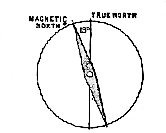
If, however, the bar be rubbed with a magnet, a peculiar change is wrought in the steel, and it no longer exhibits this indifference to direction, but, when left free, always takes up a definite position, one end pointing in a northerly and the other in a southerly, however, the bar be rubbed with a magnet, a peculiar change is wrought in the steel, and it no longer exhibits this indifference to direction, but, when left free, always takes up a definite position, one end pointing in a northerly and the other in a southerly direction. This property is taken advantage of in constructing the mariner's compass. About two hundred and twenty [11] years ago the compass pointed exactly north and south in London; but from the year 1660, or thereabouts, the end which tends northwards, and is therefore commonly called the north pole of the needle, began to turn a little to the west; this variation from true north continued until the year 1818, when it reached its greatest divergence, and since that time it has been steadily creeping back. The divergence of the position of the magnetic needle from the true north-and-south line is called its declination, or, by nautical men, its variation. In 1818 the declination amounted to nearly 25°, and in the present year (1877) it is 19° 3' in London; that is to say, the end or pole of the needle which turns in a northerly direction, instead of pointing due north, points 19° 3' to the west of true north. This declination is shown in Fig. 2. Knowing the amount of declination, it is easy to make the proper allowance and thus find the true points of the compass. By means of the compass the direction of the river in all its windings may be traced, and the course of the meandering stream laid down upon a map, as has been done, for example, in Plate I.
This map, however, does something more than show simply the direction of the Thames and its tributaries; it gives us, in addition, some notion of their length . A map, as we have seen, is a kind of picture, and the size of this picture must bear a certain relation to the size of the object represented. This relation or proportion is called the scale of the map. If a map is said to have a scale of one inch to the mile, it is simply meant that a mile measured along the ground is represented by an inch measured on the map; or a square mile of country is represented by a square inch on the map, and so on. Most of the wonderfully accurate maps of the Ordnance Survey are constructed on [12] this scale of one inch to the mile. In other words, in the map of a given district, the distance between any two points is 1/63360th of the actual distance, since there are 63,360 inches in one statute mile. The fraction which denotes the ratio of the two distances is sometimes termed the representative fraction. A map of the Thames on the one-inch scale would extend to a length of about 120 inches, since the greatest width of the basin of the river from east to west is about 120 miles. Maps on a scale even much greater than this are occasionally constructed. The Ordnance Survey, for example, issues county maps on a scale of six inches to a mile, the representative fraction being here 1/10560. But it is evident, from the size of a page of this book, that our map must be on a very much smaller scale; in fact, a mile of ground is represented there by the fourteenth part of an inch.
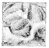
[13] In most maps, except those on an extremely small scale, an attempt is made to show something of the general features of the ground, especially whether the country is hilly or not. This is commonly effected by a system of hill-shading, such as that represented in Fig. 3.4 If the ground is steep, the lines, or hachures, are drawn thick and close together, so that the hilly spots become dark; if the ground is tolerably level, the lines are thinner and farther apart, and the general appearance of the map is consequently lighter. Such a system of shading, however effective by its combination of light and shade; shows in most cases merely that one part of the country is higher or lower than another, without enabling us to judge how much higher or how much lower. But in very accurate maps, such as those employed for military purposes, a definite scale of shade is often used. The same object may, however, be attained by an entirely different system, such as that used in the map of the Thames forming Plate I.
It will be observed that, instead of hill-shading, a number of curved lines have been traced over the map, giving it a peculiar character. These curves are called contour lines, and their meaning is extremely simple. Suppose the valley of the Thames were flooded with water, and that this water could be dammed in or prevented from escaping, by a wall built across the mouth of the valley. If sufficient water covered the ground to stand 100 feet above the level of the sea, the surface of the water would form a [14] plane, and its margin would trace a line, winding round every hill and up every valley, at a height of exactly 100 feet. Such a line has been traced on our map, and being the first of the series of curves, it is numbered 1. This is consequently the 100-feet contour-line. The second line, No. 2, is drawn at a height of 200 feet above the sea-level, and therefore represents the margin of a body of water standing in the Thames Valley 200 feet above the sea. In like manner a succession of these contour-lines has been drawn, each at a distance of 100 feet from the next one below, just as though the flood had risen in the valley and stopped at every 100 feet to leave its mark around its margin.
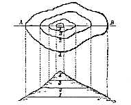
It is evident that a system of such lines conveys a far better notion of the character of the ground than can be obtained from ordinary hill-shading. Where the ground is very steep, the contour-lines run close together; where very flat, they stand far apart. The relation between the contour-lines and the form of the ground is clearly shown in Fig. 4. In the upper part of this figure, a hill is represented by contour-[15]lines; and supposing this hill were cut through, along the line A B, it would give such an outline as that drawn in the lower part of the figure, the corresponding points in the plan and the section being connected by broken lines.
Inspection of the map in Plate I. shows, as might have been expected, that the river there represented flows from high ground to low ground. In fact, if the reader were to travel up the Thames, by walking along its banks, he would find himself continually going up-hill. Between Thames Head and London Bridge, a distance of about 170 miles, as measured along the winding course of the river, there is a difference of level of 370 feet. We have seen that the head of the navigation is at Lechlade, about 146 miles from London, between Lechlade and London the river has a total fall of about 250 feet; and as the descent is tolerably uniform, it may be taken at an average of 21 inches per mile. At Teddington, where the river ceases to be tidal, the ordinary summer-level of low water is 16-1/2 feet above low-water level at London Bridge; and the fall of the bed of the river below Teddington is nearly a foot in every mile. The rapidity with which a river flows will of course depend upon the amount of slope in its bed; where the fall is great, the stream is rapid; where small, the stream is slow. The bed of the Thames, fortunately, is tolerably uniform in its descent, so that the stream is free from rapids.
What has been said of the Thames is equally true of any one of its tributary streams: the source is always higher than the mouth. It is seen from the contour-lines on the map that, if we travel along any of the little rivers which open into the Thames upon its left bank, we go up-hill in passing from south to north; if we travel along any of the streams on the opposite side of the river, we go up-hill in [16] passing southwards. As a consequence of all this, it follows that the tract of country drained by the Thames and its tributaries must be bounded on at least three sides– the west, the north, and the south–by comparatively high ground. It thus forms a shallow depression, with an outlet to the east through which the river flows out to sea. Such a depression is known as a river-basin, and the country through which the Thames and its tributaries flow is consequently called the Thames Basin , while the deepest part of the basin, that in which the main stream flows, is termed the Thames Valley. The basin of the Thames, depicted in Plate I., includes a very large tract, extending over 6,160 square miles; the Thames, in fact, drains more than one-seventh of all England.
Perhaps the term "basin," just used, is one which is likely to mislead unless properly qualified. It is true that, if you go north from any part of the valley of the Thames, you find yourself sooner or later travelling up-hill, and therefore reach higher ground than that through which the river flows; if you travel southwards, you do the same thing; while towards the west, the assent is not less marked. The river then really does occupy a hollow, inclosed on three sides by high ground. But it must be borne in mind that this hollow is nothing like the deep hollow associated with our ordinary notion of a [17] basin; it is, in fact, so slight a depression that it would perhaps be better to speak of the "dish" of the Thames rather than of its "basin." In Fig 5 the undulating line indicates the general contour of the surface of the country along a north-and-south line drawn across the basin of the Thames, from the Chiltern Hills on the north, to the North Downs on the south. The very gentle curvatures of this line show the extreme shallowness of the so-called basin; and also show the irregularities in the form of the ground. Although the opposite north and south hills may attain to a height of several hundred feet above the river, yet the distance between them is so great, amounting to some fifty or sixty miles, that the rise from the river to their summits would be almost inappreciable in a diagram brought within the limits of this page. Hence it is a common practice in constructing such diagrams to draw the heights to a scale many times greater than that used for the lengths. This has, in fact, been done in Fig. 5., where the vertical is as much as twelve times greater than the horizontal scale. Without such exaggeration, the surface of the country would appear in a small diagram to be almost flat; and even with it, the extreme shallowness of the Thames basin is strikingly apparent. There is clearly no harm in the practice of drawing diagrams on this principle, provided that the exaggeration of one dimension is always acknowledged by the draughtsman, and borne in mind by the reader. Great misconception, however, constantly arises from mistaking these intentionally distorted diagrams for true figures.
To the north-west of London, the margin of the Thames basin is formed, in part, by a line of low hills called the Chiltern Hills; and, on the south of London, there is another series known as the North Downs; while, if we go far enough to the west in the Thames basin, we come to a still [18] higher country forming the Cotteswold Hills in Gloucestershire. Suppose the reader were to ascend one of these ranges of hills, say the Cotteswolds, on the west. As he went up, he would meet with many little streams which are flowing down to feed the affluents of the Thames. But having reached the summit, and walked on in the same direction, he would soon begin to go down-hill, and then meet fresh streams running in an opposite direction to those he had left. These new streams cannot possibly flow into the Thames, for to do that the water would have to run up-hill. By following these streams, however, he would find that they ultimately flow into a river entirely distinct from the Thames; thus, on the other side of the Cotteswolds, the streams find their way, sooner or later, into the Severn. On crossing these hills, then, we have passed from the basin of the Thames into that of the Severn. The high land which forms the divisional line between two contiguous river-basins is called the water-parting .
Instead of "water-parting," some writers employ the term watershed; but although the two words originally meant precisely the same thing, the latter has become rather ambiguous. "Watershed" is a word which has been borrowed from German geographers. The verb scheiden signifies "to separate," and die Wasserscheide is simply the "water-separation" or the "parting of the waters"–the old Divortium aquarum . But many writers, looking at the common meaning of the English verb "to shed" have used the term "watershed" to denote the surface from which the waters are shed, or the slope along which they flow; hence it is not uncommon to hear such expressions as "the crest of the watershed." To avoid this double use of the word "watershed," the term "water-parting" has been introduced as the English equivalent of the German [19] Wassenscheide , or the boundary-line between two adjacent river-systems. Such a line was called by Professor Phillips "the summit of drainage"; and in the north of England, where it often separates one estate from another, it is known as "the heaven-water boundary." To avoid all ambiguity, it is perhaps best to set aside the original meaning of "watershed," and employ the term to denote the slope along which the water flows, while the expression "water-parting" is employed for the summit of this slope. Thus the ridge of a roof is the water-parting; and the slates or tiles on each side, down which the water drains, will form the watershed. It must be remembered, however, that the water-parting is not necessarily the summit of a range of hills, like the ridge of a roof. Frequently, indeed, the ground is only relatively high; but the water easily finds the slope, however small, and runs down it, thus showing at once the direction of the water-parting.
A little consideration will show that water-partings may be drawn on a map of any country, so as to divide the entire region into a series of river-basins. Plate II. is a map of Great Britain and Ireland thus completely divided into river basins, separated one from another by water-partings, which are indicated by dotted lines. All the rivers which empty themselves into the sea on the eastern side of Britain may, in this way, be separated from those which run into the western seas, and both systems may be separated from the southern rivers which open into the English Channel: the northern drainage is insignificant. We thus obtain the general water-parting of Great Britain, distinguished in the map by a line of red dots. This is a sinuous line running from near John-o'-Groat's House, through Scotland and the north of England, down the Peak of Derbyshire and through the Midland counties, till it gets [20] as far south as Salisbury Plain. Such a line divides the western drainage of the country from its eastern drainage. At Salisbury Plain the line splits into two branches, one stretching to the east coast and terminating somewhere about Dover, the other striking to the west coast and terminating at the Land's End. To the south of this great east-and-west line, all the rivers flow into the English Channel. This three-branched line consequently represents the main water-parting of the country; it is in fact the general high-level line of Britain, though it has no direct relation to the mountain-systems of the country. The main water-partings of Ireland are also indicated on the map, the rivers being grouped in four great systems, which drain to the north, south, east, and west.
We shall restrict our attention, for the present, to one of these river-basins of England–the basin of the Thames– and endeavour to extract from its study as much instruction as possible. In several of the succeeding chapters we shall therefore inquire how this basin is fed with water, by what means it has received its present shape, and what has been its history in the past. Even the first question–how the basin is fed–suggests prolific material for study. It is true we have, in the present chapter, traced the Thames to its head-waters, but it must not for a moment be supposed that by doing this we have yet reached its real origin. The streams and springs from which a river is popularly said to take its rise are in truth only its proximate sources, and the ultimate source is to be sought elsewhere. In seeking that source, the inquiry may fitly be commenced by examining more closely into the nature and origin of springs.
1 Many of the statistical data relating to the Thames have been obligingly furnished by Mr. Leach, of the Thames Conservancy Board. 2 Affluent, from the Latin ad and fluo, "to flow." The junction of an affluent with the main stream is termed the confluence , place where they "flow together." Thus, the town of Coblenz takes its name from the Latin form Confuentes, in allusion to its position at the junction of the Moselle and the Rhine. 3 It is the practice of astronomers to distinguish the several stars of a particular group, or constellation, by means of Greek letters. Thus the two stars in the Great Bear, known as the Pointers, since a line joining them points towards the pole-star, are distinguished in Fig. I by the letters
4 This figure is copied from part of sheet 59 of the one-inch Ordnance map of England and Wales, and shows the physical characters of a district in North Wales. The portion of the map here copied is a square measuring two inches along each side, so that the total area represented in Fig 3. amounts to four square miles.
[185]
All the natural agents described in the last three chapters, however much they may differ among themselves, agree in this–that they are, upon the whole, slow and certain agents of destruction. Rain and river, frost and thaw, wind and wave– all work in the same direction, persistently attacking the solid land and sweeping away its superficial substance. Not that a particle of this substance is annihilated. Every grain stolen from the land is sooner or later carefully deposited somewhere in the sea. But, still, this gradual transference of matter, from land to water, must ultimately result in the lowering of the general level of the land to that of the sea by the action of the rain and rivers; and, in the subsequent paring down of the plain, thus formed, to the depth at which marine denudation becomes insensible. If, therefore, no hindrance were offered to the action of these agents, not only would a time come when every foot of the British Isles would be buried beneath the sea; but, inasmuch as the volume of the sea is very much greater than that of the land which rises above the sea-level, if sufficient time were granted, all the dry land in the world would ultimately disappear beneath one universal sheet of water.
[186] It is not difficult, however, to detect in the operations of nature, counterbalancing forces which are capable of upheaving the deposits that have been formed on the sea-bottom, and of piling up fresh stores of solid matter upon the surface of the earth. Among these elevatory, and therefore reparative, agents, the most important place must be assigned to those which give rise to earthquakes and volcanoes. After the occurrence of an earthquake, it is by no means uncommon to find that the level of the land has been shifted. Sometimes, it is true, the surface is depressed, but more commonly the movement is in the direction of elevation.
Perhaps the best recorded example of such upheaval is that which was observed by Admiral Fitzroy and Mr. Darwin when examining the western coast of South America. This region is peculiarly subject to subterranean disturbances, and in 1835 a violent earthquake, which destroyed several towns, was felt along the coast of Chile, extending from Copiapo to Chiloe. It was found, after the shock, that the land in the Bay of Concepcion had been elevated to the extent of four or five feet. At an island called Santa Maria, about twenty-five miles southwest of Concepcion, the upheaval was easily measured, vertically, on the steep cliffs; and the measurements showed that the south-western part of the island was raised eight feet, while the northern end vas lifted more than ten feet high. Beds of dead mussels were, in fact, hoisted ten feet above high-water mark; and an extensive rocky flat, previously covered by the sea, was exposed as dry land. In like manner, the bottom of the surrounding sea must have been elevated, for soundings all round the island became shallower by about nine feet. It is true, there was a partial subsidence shortly afterwards, but this was far from sufficient to neutralize the upheaval, and the net result showed a permanent elevation. It is considered [187] probable, that the greater part of the South American coast has been raised several hundred feet by a succession of such small upheavals.
When an area is thus raised, the addition suddenly made to the mass of dry land may be very considerable, and will compensate for the effects of denudation continued through a long period. It was calculated, for example, by Sir C. Lyell, that, during an earthquake which occurred in Chile in 1822, a mass of rock more than equal in weight to a hundred thousand of the great pyramids of Egypt was added to the South-American continent. If a single convulsion of this kind can thus raise such an amount of solid land from beneath the waters, it is obvious that these movements must be of great service in renovating the surface of the earth, and in bringing new material within reach of the ever-active agents of denudation. It is proper to remark, that an earthquake-wave is a vibration of the solid crust of the earth, which may, and constantly does, occur, without giving rise to any permanent change in its form. Nevertheless, the wave is often accompanied by movements of elevation, or of depression, which produce permanent alterations of level of considerable magnitude.
An earthquake is just such a disturbance of the ground as would result from a sudden shock, or blow, given upwards in the interior of the earth, from which, as from a centre, waves or tremors may be propagated in all directions through the solid ground. In many cases, the shock is preceded or accompanied by a rumbling noise, like that of distant thunder, or by other sounds produced by the subterranean disturbances The earthquake-wave, as it travels along, causes the ground to rise and fall, and frequently produces irregular fissures, which may close again and thus bury whatever has been engulfed, or may remain open as yawning chasms, and thus modify the drainage of the country. The [188] impulse may be transmitted through the earth to an enormous distance; the great earthquake which destroyed Lisbon in 1755, having made itself felt, directly or indirectly, on the waters of Loch Lomond in Scotland. If the centre of disturbance is near the sea, the water is affected even more than the land, and the water-waves may be far more destructive than the earth-waves. News has recently reached this country of the terrible devastation wrought by the great tidal wave which followed the earthquake at Lima, Arica, Iquique and other points of the coast of South America in May, 1877.
A good deal of attention has been paid by Mr. R. Mallet to the study of earthquake phenomena, or Seismology,1 and he is led to conclude that the origin of the disturbance is usually not deep-seated in the interior of the earth, probably never exceeding a depth of thirty miles; while in many cases, it is certainly much less. Thus he ascertained that the great Neapolitan shock of 1857 had its origin at a depth of only eight or nine miles beneath the surface. Dr. Oldham has since found that a great earthquake at Cachar, in India, in 1869, had its focus, or centre of impulse, at a depth of about thirty miles.
Although earthquake-shocks are happily of rare occurrence in this country, it must be remembered that, in many parts of the world, they are by no means rare phenomena; and, probably, it is not overstating the case to say that earthquake shocks occur, on an average, about three times a week. During the year 1876, for example, no fewer than 104 earthquakes are recorded in Professor Fuchs's Annual Report; and, in the preceding year, as many as 100 days were marked by the occurrence of shocks. But, in addition to these, there are no doubt many slight disturbances, in [189] unfrequented districts, which are never recorded in such reports. The total effect produced by the causes of such disturbances must consequently be far from insignificant, even in the course of a single year.
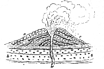
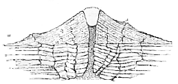
Subterranean disturbances which commence merely with quakings of the ground often terminate with the forcible ejection of heated matter from the interior of the earth. A rent may be produced at some weak point, and this crack then serves for the passage of large volumes of steam and other vapours, with showers of red-hot ashes, accompanied or followed by streams of molten rock. The solid materials are shot forth into the air, and fall in showers around the mouth of the orifice; where they form, by their accumulation, a cone-shaped mound or hill. Such a hill is called a volcano,2 or popularly a "burning mountain." It must be borne in mind, however, that it does not "burn," in the sense in which a fire burns, but it merely offers a channel through which heated matter is erupted from below. It differs again from an ordinary mountain, in that it is simply a heap of loose materials and melted matter, which has been piled up, layer after layer, around a hole leading down to the anterior of the earth. Hence, if a volcano were cut through, it would probably present a section something like that shown in Fig. 50. Here a channel, a, has been opened through strata, b, b, originally horizontal, and the ejected matter has fallen all round the orifice in conical layers, each forming a mantle thrown irregularly over the preceding layer, and sloping in all directions away from the central chimney.
At the mouth of the volcanic pipe, there is usually a funnel-shaped opening known as the crater. Fragmentary materials falling back into this cup, or rolling in from the sides, form layers which slope towards the vent and there[190]fore in the opposite direction to the dip of the volcanic beds which make up the mass of the mound. A section of a cone of loose cindery materials is given in Fig. 51, and shows the difference of dip just referred to. The molten matter which wells up the throat of a volcano, cements the loose ashes and cinders into a compact mass, where it comes in contact with theme and thus forms a hard stony tulle lining the volcanic chimney.
At the beginning of an eruption, clouds of steam are copiously belched forth, showing that water has its part to play even in these fiery phenomena The steam generally issues spasmodically, each puff giving rise to clouds which shoot up to a great height, and are either dissipated or condensed in torrents of rain. Associated with the steam are various gaseous exhalations, most of which, however, are not combustible. Hence, the appearance of a column of flame, often said to be seen issuing from a volcano, must generally [191] be an illusion, due to illumination of the vapours, partly by sparks and red-hot stones and ashes shot out at the same time, and partly, by reflection from the glowing walls of the pipe and from the surface of the molten matter below. In the early stages of an eruption, huge fragments of rock may be ejected; for when, after a period of repose, the pent-up steam and gases at last gain vent, they violently eject the materials which have accumulated in the throat of the chimney, and choked its opening. Masses of rock, some as much as nine feet in diameter, are said to have been cast forth from the great volcano Cotopaxi, in Quito, during the eruption of 1553, and to have been hurled to a distance of more than fifteen miles from the mountain.
During an eruption, ashes are commonly ejected in great quantity, but it must be borne in mind that the materials so-called are very different from the partially-burnt fuel of the domestic hearth. Volcanic ashes are, in fact, nothing but fragments of lava, or partially-fused rocky matter. When jets of this lava are shot forth from the volcano, the liquid is broken up by the air, and so splashed about that it falls in drops, which harden into small spongy fragments, resembling ashes and cinders. In some cases, the lava is broken into such fine particles that it is known as volcanic dust or sand; [192] dense showers of such dust have been known to darken the sky for miles around the volcano, and have been wafted by winds for even hundreds of miles. It is an interesting fact, shown by the examination of the sea-bottom by the Challenger, that volcanic detritus is almost universally distributed over the floor of the deep sea.
When the steam, which is abundant in most eruptions, condenses in torrents of rain, the volcanic dust is frequently worked up into a hot mud which rolls down the hill in a sluggish stream, burying everything before it. Herculaneum was sealed up by a crust of volcanic mud discharged from Vesuvius; while Pompeii was overwhelmed by a vast accumulation of dust and ashes during the same eruption.
The partially-molten rock called lava rises up in the volcanic pipe, and may eventually run over the lip of the crater, or force its way through cracks in the hill, forming red-hot streams which generally present a consistence something like that of treacle. These lava-torrents are often of great magnitude; thus, it was estimated that in the famous eruption of Skaptar Jokul, in Iceland, in 1783, the mass of lava brought up from subterranean regions was equal to the bulk of Mont Blanc. The lava rapidly cools on the surface, though long retaining its heat beneath the protecting crust; and, ultimately, the entire mass solidifies, forming a hard rock, more or less like a slag from an iron-furnace. In different specimens, however, the lava exhibits great variations; some being dark-coloured and comparatively heavy, while others are lighter in colour and much less dense; in some cases the rock is compact, while in others it is spongy or cindery, when it is said to be scoriaceous. The little cavities, or vesicles, in this scoria,3 or cellular lava, are formed by the disengagement of bubbles of gas or vapour, [193] when the matter is in a pasty condition; just as the porous texture of a piece of bread is due to the presence of bubbles of gas evolved by the fermentation of the yeast. The stone largely used for scouring paint under the name of pumice4 is a lava of very porous texture; its name recalling its origin as the froth or scum of lava. Sometimes, the masses of lava, which are tossed into the air, are rotated during their flight, and fall as more or less rounded bodies, known as volcanic bombs. Occasionally a very liquid lava may be caught by the wind, and drawn out into delicate fibres, like spun glass; this beautiful form is very abundant at Kilauea, a volcano in Hawaii, one of the Sandwich islands, where it is known as Pélé's hair, its name being borrowed from that of an old goddess who was supposed to reside in the crater. Other lavas again are vitreous, and strongly resemble dark-coloured bottle-glass, when they pass under the name of obsidian. This kind of lava was largely used by the ancient Mexicans for making rude knives and other cutting instruments; and a hill in northern Mexico, formerly worked for this material, is still known as the Cerro de Navajas (Spanish "Hill of Knives.")
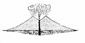
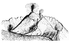
It often happens that the lava which wells up in the pipe of a volcano, breaks by its sheer weight through the rim of the crater, or even breaches one side of the conical hill. Thus Fig. 52 represents a group of small extinct volcanoes in Central France, showing cones which have been broken through in this way. In some cases the flanks of the cones are rent, and lava is then injected into the cracks, forming, when cold, huge rocky ribs known as dykes. In other cases, the chimney gets choked by a plug of hard lava, and new vents may then be opened on the side of the cone. Fig. 53 [194] is that of an ideal section of a volcano, showing the dykes of lava running through the stratified deposits, and also showing two minor cones a b, thrown up at points where the volcanic matter has been able to force its way to the surface. Mount Etna is remarkable for having its flanks studded with parasitic cones, some of which are of considerable size, one being upwards of 900 feet in height.
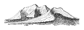
After a volcano has long been silent and the larger crater has been more or less filled, partly by ejected materials which had fallen back into the cavity during the last eruption, and partly by matter washed in by rain, renewal of activity through the old channel may give rise to the [195] formation of a new cone seated within the old crateral hollow. Great changes may indeed be effected in the character of a volcano by successive eruptions, new cones being thrown up at one time, and old ones obliterated at another. Fig. 54, shows the summit of Vesuvius as it appeared in I756, when there were no fewer than three separate cones, one within another, encircling as many craters. But about ten years afterwards the summit presented the form shown in Fig. 55, where a single cone rises from the floor of the great crater. The curious stages through which a volcano may pass are well illustrated by the story of Vesuvius.
Rather less than two thousand years ago, that mountain was as peaceful as Primrose Hill is at the present day. It seems from all accounts to have had a very regular conical shape, with a crater about a mile and a half broad. Yet its shape led hardly any one to suspect that the mountain was a slumbering volcano. Wild vines were growing over the [196] sides of the crater, and it was in the natural fortress formed by this great amphitheatre that Spartacus the Thracian, with his little band of gladiators, took up his position at the beginning of the Servile War in the year 72 B.C. Earthquakes, as already pointed out, are often the heralds of volcanic eruptions; and the first notice which the old dwellers around Vesuvius received of its renewed activity was from a series of earthquakes which began, as far as we know, in A.D. 63, and continued intermittently for about sixteen years. These disturbances culminated in the great eruption of A.D. 79, which has been described in two letters written by Pliny the Younger to Tacitus.
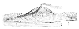
The elder Pliny, the author of the famous Historia Naturalis, was, at that time, in command of the Roman fleet off Misenum. On the 24th of August a cloud of unusual size and shape was seen hanging over the mountain. It is described as having had the form of a huge pine-tree; and similarly-shaped masses of cloud usually accompany the eruptions of Vesuvius. An [197] enormous column of steam, mingled with ashes and stones, shoots up from the crater to a height of a thousand or twelve hundred feet, where the clouds spread out in horizontal masses, some miles in breadth, while the ashes and stones fall down in showers. Attracted by so curious a sight, the elder Pliny went to Stabile, about ten miles from Vesuvius, but his eagerness to witness the spectacle cost him his life. His nephew, who stayed at Misenum, describes the scene–the showers of ashes, the ejection of red-hot stones, the movement of the land, the retreat of the sea, and other phenomena characteristic of the eruption of a volcano attended by an earthquake. So vast were the quantities of ashes and other fragmentary matter ejected, either dry or mixed with water, that the unfortunate cities of Herculanæum, Pompeii, and Stabiæ were buried beneath deposits, in some places, thirty feet in thickness. It is doubtful, however, whether any true lava was erupted on this occasion. From that date to the present day, Vesuvius has been more or less active, though sometimes quiet for considerable intervals. During the great eruption just referred to, the southwestern side of the original cone was destroyed, but the half which was then left has remained in existence up to the present time, and forms the semi-circular hill known as Monte Somma. Fig. 56 is a view of Vesuvius half encircled by the cliffs of this ancient crater.5
When a volcano is situated near the coast–and by far the larger number of existing volcanoes are so situated–the ashes may be showered into the sea, or be borne thither by the wind, and may, in this way, get mixed with the detrital matter which is spread over the sea-bottom. A curious series [198] of deposits may thus be produced, consisting partly of materials worn away from the land by the action of the water, and partly of matter ejected from subterranean
sources. In some cases, volcanic outbreaks take place actually beneath the sea, and the matter thrown up becomes mixed with the remains of shell-fish and other marine organisms. Submarine volcanoes occasionally give rise to
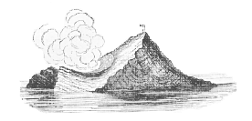
new land, the erupted matter being piled up in sufficient quantity to form an island rising above the waters. Thus, in the year 1831 an island, which Admiral Smyth named [199] Graham Island (Fig. 57) appeared in the Mediterranean, between Sicily and the coast of Africa, where there had previously been more than 100 fathoms of water. The pile of volcanic matter forming this isle must have been upwards of 800 feet high, for the highest part of the island was 200 feet above water; while the circumference of the mass of land was nearly three miles. After it had stood above the waves for about three months, the island entirely disappeared.
It is obvious that a great deal of the force by which volcanic products are brought to the surface is due to the conversion into steam of water which, in some way or other, obtains access to the deep-seated molten rocks; but, whether this is the sole source of volcanic energy or not, is uncertain. Numerous hypotheses have been advanced to explain the source and origin of the molten matter itself. Some of these attempts at explanation refer the heat to chemical and some to mechanical causes; while others assume that it is merely the residue of the heat which the earth originally possessed, if, as seems likely, it existed at one time in a state of fusion. Dismissing, however, these vexed questions, it is sufficient to remark that some source of heat unquestionably does exist in the earth beneath our feet.
If a thermometer be buried in the ground at a depth of only a few inches below the surface, it is found to be affected by all superficial changes of temperature, and its indications show that it is cool at night and warm in the day, cold in the winter and hot in the summer. But plunged deep into the ground, or placed in a deep cellar or cavern, these variations disappear, and one uniform temperature is registered under all circumstances. What that temperature is will depend principally on the climate of [200] the locality, the constant temperature being nearly the mean temperature of the surface.
On going still deeper, the heat is found to increase; and, at the bottom of a deep mine, it is generally so warm that the miners are glad to discard most of their clothing. At present, the deepest mine in this country is the Rosebridge Colliery, at Ince, near Wigan, which has reached a depth of 2,445 feet. Experiments on the temperature at different depths, while sinking this pit, showed that the average increase is about 1° Fahr. for every fifty-four feet. In other sinkings, somewhat different results have been obtained, the rate of augmentation being affected by the character of the rocks bored through and by the position which the strata occupy; whether, for example, they are inclined or horizontal. Thus at the Astley pit at Dunkenfield in Cheshire the rate was found to be 1° for every seventy-seven feet, but this appears to be unusually slow. Perhaps it will not be far wrong to assume that the average increase is 1° for every sixty feet: such at least is the rate which was adopted a few years ago by the Royal Coal Commission in their calculations.
Even the deep sinking at the Rosebridge Colliery is but the veriest dent in the earth's surface compared with the actual radius of the globe. It gives therefore but scant information respecting the temperature of the deep-seated portions of the interior; but, assuming such a rate of increase to continue, it is evident that at the depth of only a few miles the heat would be sufficient to fuse any known rock. It is true that the melting-point of a solid body may be greatly modified by pressure; and it is obvious that, at great depths, the pressure must be prodigious. Nevertheless, the eruption of lava from volcanic vents sufficiently shows
[201]
[202] that, whatever the general state of the earth's interior, there must be at least local masses of molten rock.
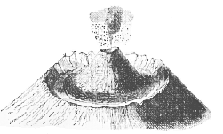
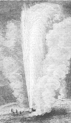
Additional evidence of the existence of heat at great depths is furnished by the temperature of the water yielded by certain springs. Some of the hot springs at Bath, for example, have a temperature of 120° F. Still hotter springs occur in many countries; and, in volcanic districts, even the boiling point is occasionally reached. The most remarkable of these hot springs are those known in Iceland as Geysers. Jets of boiling water with clouds of steam are intermittently thrown high into the air with great force and accompanied with loud explosions. The water generally holds silica in solution, as mentioned on p. 124, and this siliceous matter is deposited around the mouth of the hole as an incrustation called sinter. Although the Geysers of Iceland are best known, similar springs are found in New Zealand, and also in the Rocky Mountains of North America. Fig. 58, represents a geyser in the Yellowstone Park, described by Prof. Hayden. No fewer than 10,000 hot springs, geysers, and hot lakes are said to exist within the area of the Yellowstone Park. The geyser, here represented in action, throws jets of hot water to a height something like 200 feet.
In some localities, hot water issuing from the ground is mixed with earthly matter; and streams of thick mud accumulate round the openings, so as to form conical hills, known as salses, or mud volcanoes. Such eruptions of mud, varying considerably in consistency and in temperature, occur, for example, in the Crimea, and on the shores of the Caspian Sea. In other cases, hot vapours issue from cracks in the ground, as at the Solfatara, near Naples, where the vapours are charged with sulphur. A large industry has sprung up in the Tuscan Maremma, by utilizing the hot vapours which issue from smoking cracks, known as soffioni, and contain [203] particles of boracic acid which are used in the preparation of borax.
Most of the phenomena just described, are probably to be regarded as representing the lingering remains of volcanic activity. When a volcano has become extinct, the effects of subterranean heat in the locality may still manifest themselves in a subdued form, in such phenomena as those of hot springs. Many volcanoes, however, which appear at the present day to be perfectly quiet, are merely dormant, and may break forth with renewed activity at any moment. The early history of Vesuvius, as already pointed out, shows that a volcano, after being silent for ages, may suddenly start forth into fresh life.
There are few better examples of an area in which volcanic action must have been rife on an enormous scale at a comparatively recent time, than that furnished by the Auvergne and the neighbouring districts in Central France. There the traveller may see hundreds of volcanic cones, known locally as "puys," still preserving their characteristic shape, in spite of long exposure; there, too, are the streams of lava just as they flowed from the craters, or burst through the sides of the cones (Fig. 52), whilst thick sheets of old lava and beds of ash are spread far and wide over the surrounding country. The district known as the Eifel, on the west bank of the Rhine, between Bonn and Andernach, offers equally striking examples of extinct volcanoes.
Even in the British Isles, it is not difficult to trace the remains of ancient volcanic outbursts, although these are not so fresh and well-marked as those just mentioned. Sheets of lava are found in the north-eastern part of Ireland, especially in the county of Antrim where the remarkable scenery of the Giant's Causeway is due to the fact that some of the old lava has split up into columns, not altogether unlike [204] those into which a mass of starch splits during drying. Similar evidence of volcanic action may be found in Scotland, whilst in North Wales there are extensive remains of eruptive rocks; the state of fiery activity which they indicate dates back, however, to a very remote period of geological history. Yet it must not for a moment be supposed that any volcanic product still exists, as a crater, amongst the volcanic hills of Wales. So great indeed has been the disturbance and de mutilation of this part of the earth, that the old surface has long ago been swept away, and its present shape bears little or no relation to its form at the period of eruption. It is true, for example, that the summit of Snowdon is formed of volcanic rocks, yet the mountain, in its present form, does not in any way represent an old volcanic cone.
Without pursuing this subject further, enough has been said to prove that peaceful as our islands now are, they have again and again been the scene of violent volcanic disturbances. Fire, indeed, has played as important a part as water in the geological history of the British Isles; and it is highly probable that, at a depth, which, as compared with the diameter of the earth, may be justly termed insignificant, even the peaceful valley of the Thames is underlaid by an ocean of molten rock.
1 Seismology, from [...] seismos, a shock or earthquake. 2 Volcano, Italian vulcano, from Vulcan, the Roman god of fire. 3 Scoria, volcanic cinder, from Lat. scoria, "dross." 4 Pumice, from the Lat. pumex, formerly spumes, allied to spuma, "froth." 5 Figs. 51 to 57 are taken, by Prof. Judd's permission, from the late Mr. Poulett Scrope's work on Volcanoes.
|
THE
HUXLEY
FILE
|
| ||||||||||||||||||||||||||||||||||||||||||||||||||||||